
You are viewing an archived web page that is no longer maintained. View current CISN web pages
Details | Ground motions | Maps | Waveforms | Related links
| Information from the CISN & NEIC | |
| Date & Time (Local): | 2005/06/14 07:50:54 PM (PDT) |
| Date & Time (UTC): | 2005/06/15 02:50:54 (UTC) |
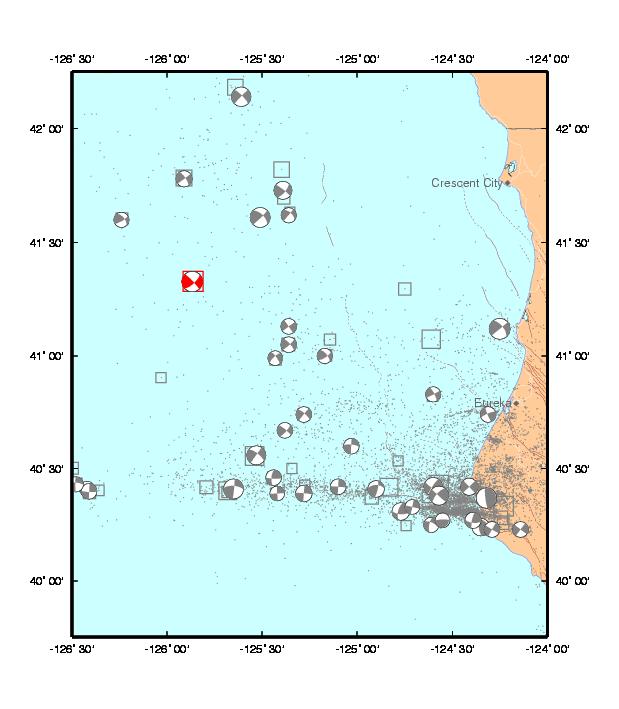
| Location: | 146 km West of Crescent City, CA 41.329N, 125.863W |
| Depth (km): | 10.0 |
| Magnitude: | 7.2 Mw |
 June 19th, 2005 (local time): An M4.9 aftershock occurred today.
June 16th, 2005 (local time): A M6.7 aftershock occurred today, at 10:21 PM local time and 06:21 UTC (on the 17th). The occurrence of this event to the southwest is consistent with the rupture model and with the aftershock pattern of the M7.2 1980 Eureka earthquake
June 15th, 2005 (local time): The magnitude of the earthquake was revised from M7.0 to M7.2, based on the results from the Havard Centroid Moment Tensor solution.
June 14th, 2005 (local time): This earthquake occurred 91 miles WSW of Crescent City, CA in the middle of the Gorda Plate to the west of the sea-floor expression of the Cascadia Subduction Zone. This quake was widely felt along the northern California - southern Oregon coast line, although only light shaking occurred.
Preliminary analysis of the quake indicates that the motion occurred on a NE striking strike-slip fault similar to other sequences that have occurred in this region. This earthquake did not produce a tsunami. Earthquakes with strike-slip mechanisms are less likely to produce tsunami because they cause relatively little vertical ground motion.
Earthquakes are common in the Gorda plate, which is subjected to north-south compression due to the north-west moving Pacific Plate that collides with the southern boundary of the Gorda Plate along the east-west Mendocino Fracture Zone. This quake occurred approximately 67 miles west of the epicenter of the November 8, 1980 Ms 7.2 earthquake. There have been 3 other quakes of magnitude M>6 that have occurred with 50 miles radius of the epicenter of this quake (August 16, 17 1991 and July 24 1996).
This is the largest earthquake in California since the 1999 M7.2 Hector Mine event and the 5th earthquake over magnitude 7 during 2005.
This event occurred just outside of the boundary used for the CISN for earthquake notification. A small earthquake in the Geysers area occurred a few minutes after the M7.2 (~07:57 PDT). Preliminary estimates of the magnitude for the Gesyers event were contaiminated by energy from the offshore earthquake. The current estimated magnitude is 3.9, although this may be revised.
The CISN routinely produces ShakeMaps for events of M3.5 and higher. ShakeMaps are based on the observed ground motions from seismic instruments combined with predicted motions in areas without sensors.
The CISN Engineering Data Center produces reports showing details of ground motions for events of interest. The have issued an Internet Quick Report (IQR) for the M7.2 showing records from Crescent City and Eureka:
Many earthquakes in this swarm have been widely felt. People with Internet access can report their observations of shaking and damage through the Did You Feel It? Web site. In the links below, you can see the maps illustrating the reported intensities for several events in this sequence. Unlike the ShakeMaps - which are based on data from seismic instruments - these maps are based on human observations. You can contribute to these data by filling out the form for each event.
Below are links to waveforms for the 7.2 Mw event.
These links will take you to seismocams showing current earthquake activity.