

You are viewing an archived web page that is no longer maintained. View current CISN web pages
Details | Ground motions | Maps | Waveforms | Related links
| Information from the CISN | |
| Date & Time (Local): | 2004/06/15 03:28:49 PM (PDT) |
| Date & Time (UTC): | 2004/06/15 22:28:49 (UTC) |
| Location: | 44 miles WSW of Coronado, CA 32.383 117.847W |
| Depth (km): | 10. |
| Magnitude: | 5.3 ML |
|
San Diego and vinicity were shaken by a moderate earthquake on Tuesday, June 15th at 3:28 PM. The event occurred offshore of Baja California, near Rosarito, Mexico. Although it was widely felt, no reports of significant damage have been received. Because this event occurred offshore, the nearest CISN station was over 76 km away. The location outside of the network created complications for the automatic earthquake monitoring system and an initial, erroneous location near Lancaster was reported. A more complete report on the earthquake will be provided when available.
|
|
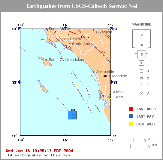
| Map showing the location of the M5.3, with a small (M3.0) foreshcok and M3.6 aftershock, as of 6/16/2004 at 10:28 AM PST. |
The CISN Southern California Management Center produces ShakeMaps for events of M3.5 and higher. ShakeMaps are based on the observed ground motions from seismic instruments combined with predicted motions in areas without sensors. Recent progress through the CISN led to the installation of more than a dozen strong-motion stations in the San Diego area by the California Geological Survey.
The CISN Engineering Data Center produces reports showing details of ground motions for events of interest.
Although this event was offshore, it was felt over a wide area of southern California. People with Internet access can report their observations of shaking and damage through the Did You Feel It? Web site. In the links below, you can see the maps illustrating the reported intensities for several events in this sequence. Unlike the ShakeMaps - which are based on data from seismic instruments - these maps are based on human observations. You can contribute to these data by filling out the form for each event.
Below are links to waveforms for the 5.3 ML event.