Magnitude 6 Earthquake NE Nevada
Preliminary Report: February 24, 2008
Prepared by Douglas Dreger and Sean Ford
On February 21, 2008 at 14:16:02 UTC a magnitude 6 (Mb 6.3, Mw6.0) earthquake occurred at 41.153 N, 114.867W, 10 km ENE of Wells, Nevada.
Substantial damage in the historical section of the town was sustained.
Moment Tensor Solution
We have updated our moment tensor solution for the event making use of 47 EarthScope Transportable Array, and ANSS broadband seismic stations (Figure 1). The normal mechanism is consistent with the trend of basin and range faulting in the region. The solution we obtain is consistent with other reported mechanisms. We obtained a moment magnitude, Mw, of 5.9. The range of Mw from the various estimates is from 5.8-6.0.
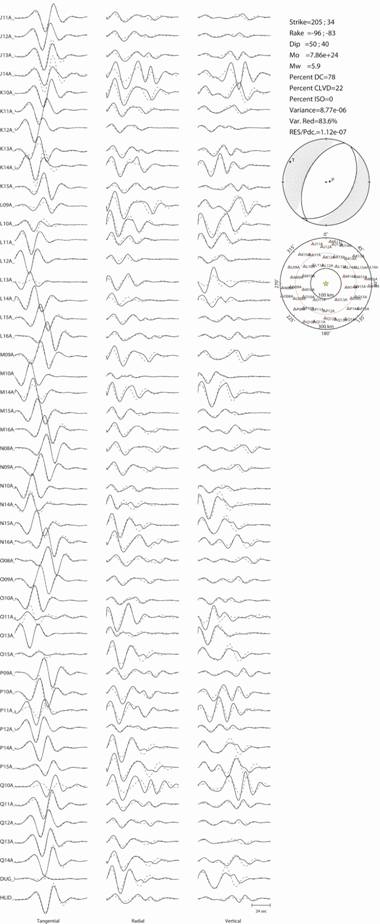
Figure 1. Deviatoric moment tensor inversion using 47 TA and US network broadband stations. The stations provide exceptional azimuthal coverage. The fit is very good (83.6% variance reduction). The Green’s functions were computed with the Song et al. (1996) model appropriate for the region. The scalar seismic moment ranges from 7.86-8.89 x 1024 dyne cm for source depths of 7 and 10 km respectively. The solution for a source depth of 7 km is plotted. The Mw is 5.9.
Finite-Source Inversion
We have inverted the three-component, broadband (f > 0.02 Hz) displacement waveform data recorded at 7 US and TA network stations (Figure 2) for a finite-source model. The preliminary results indicate that the SE dipping fault plane of the moment tensor solution (Figure 1) best satisfies the data. We will update this report with a more thorough sensitivity analysis of the causative fault plane.
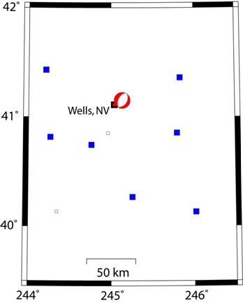
Figure 2. Location map showing the moment tensor solution, the locations of 7 broadband stations (blue squares) used in the finite-source inversion, and the location of the town of Wells, Nevada (red/black square).
The slip distribution (Figure 3) was found to be bilateral with the largest slip patch located to the south of the epicenter (Figure 3). The peak slip was 68 cm, and the scalar moment 7.97 x 1024 dyne cm (Mw5.9). Although not well resolved the best rupture velocity was 2.8 km/s corresponding to 78% of the shear wave velocity. A rise time of 0.3 seconds was assumed. The linear inverse method is based on Hartzell and Heaton (1983) as applied in Kaverina et al. (2002).
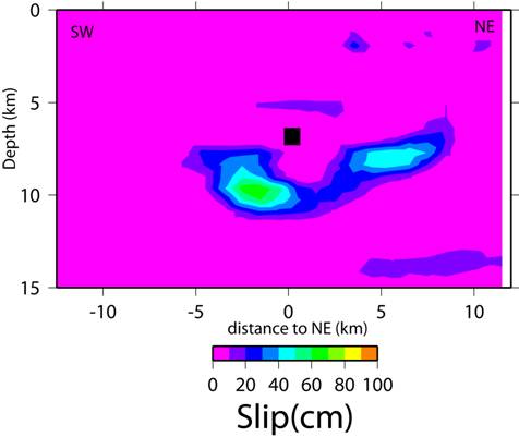
Figure 3. Slip distribution from the inversion of 7 three-component, broadband displacement records. The hypocenter at 7 km depth is shown as the black square. The rupture is down dip and bilateral. The slip outside the main two asperity patch is not considered to be well resolved.
Figure 4 shows the very good (variance reduction of 55%) fit to the data. In contrast the NW dipping nodal plane (Figure 1) was found to only fit the data at 44%. In Figure 5 the fit of both the preferred SE-dipping, and NW-dipping fault plane models are compared over a range of rupture velocity. For all rupture velocity the SE-dipping plane is superior to the NW-dipping plane. The best rupture velocity of 2.8 km/s (78% of the shear wave velocity), although the fit curve is not strongly peaked.
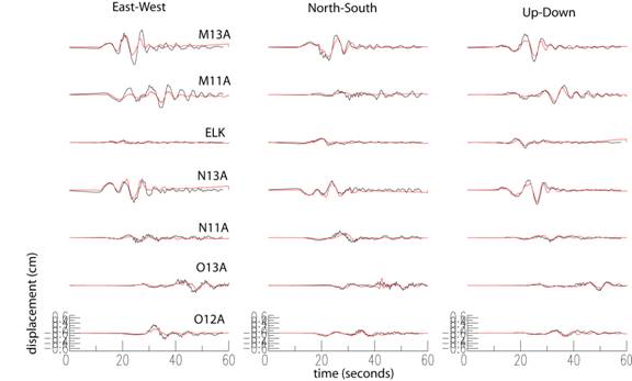
Figure 4. Observed (black) and synthetic (red) seismograms computed with the slip model shown in Figure 3. The fit is very good with a variance reduction of 55%.
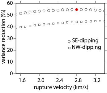
Figure 5. The SE-dipping plane consistently fits the data better than the NW-dipping plane. The best rupture velocity is 2.8 km/s (red circle).
In Figure 6 the slip is plotted in map view to illustrate its relative location to Wells, Nevada, which suffered significant structural damage.
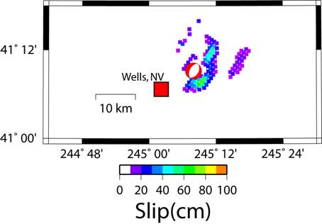
Figure 6. Location of Wells, Nevada and the slip obtained from the finite-source inversion.
References
Hartzell, S. H., and T. H. Heaton (1983) Inversion of strong ground motion and teleseismic waveform data for the fault rupture history of the 1979 Imperial Valley, California, earthquake, Bull. Seism. Soc. Am., 73, 1553-1583.
Kaverina, A., D. Dreger, and E. Price (2002) The combined inversion of seismic and geodetic data for the source process of the 16 October 1999 M (sub w) 7.1 Hector Mine, California, Earthquake, Bull. Seism. Soc. Am., vol.92, no.4, pp.1266-1280.
Song, X. J., D. V. Helmberger and L. Zhao (1996). Broad-band modelling of regional seismograms; the basin and range crustal structure, Geophys. J. Int., 125(1), 15-29.