

You are viewing an archived web page that is no longer maintained. View current CISN web pages
Details | Ground motions | Maps | Waveforms | Related links
| Information from the CISN | |
| Date & Time (Local): | 2005/06/16 01:53:25 PM (PDT) |
| Date & Time (UTC): | 2005/06/16 20:53:25 (UTC) |
| Location: | 5 km NE of Yucaipa, CA 34.058N, 117.011W |
| Depth (km): | 11.8 |
| Magnitude: | 4.9 Mw |
 June 27th, 2005:
An M4.0 earthquake occurred today, within the aftershock area of the
6/16 M4.9 event. The M4.0 event is located only about 1.0 km to the
west of the M4.9 hypocenter and about 1.0 km shallower. It exhibited
strike-slip motion, most likely on the left-lateral plane or the plane
striking at a high angle to the direction of the San Andreas fault.
June 27th, 2005:
An M4.0 earthquake occurred today, within the aftershock area of the
6/16 M4.9 event. The M4.0 event is located only about 1.0 km to the
west of the M4.9 hypocenter and about 1.0 km shallower. It exhibited
strike-slip motion, most likely on the left-lateral plane or the plane
striking at a high angle to the direction of the San Andreas fault.
In detail, the aftershocks form two subparallel clusters that trend almost east-west and are offset by a few hundred meters. This latest M4.0 aftershock is probably associated with the westernmost cluster.
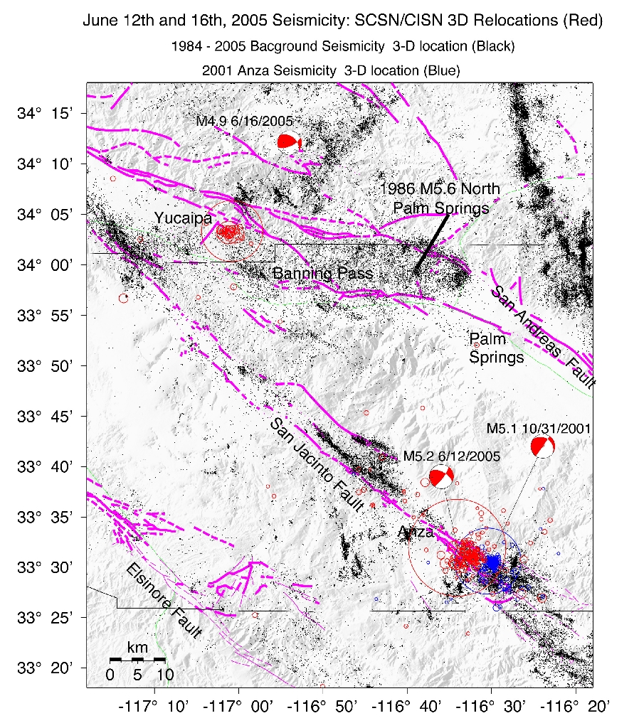
June 16th, 2005: A magnitude Mw4.9 earthquake occurred 4 km (2 miles) northeast of Yucaipa, California at 1:53 pm on Thursday, 16th of June 2005. The mainshock focal depth was about 13 km (8 miles). The earthquake is located near the Banning strand of the southern San Andreas fault zone. The event occurred on an almost east-west striking vertical fault with thrust motion and a small left-lateral strike-slip component. It is consistent with uplift of topographic features in the area, such as the Crafton Hills. This figure shows this event and its aftershocks in cross section with background seismicity.
The earthquake was widely felt across southern California, particularly in the Inland Empire and the greater Los Angeles basin. The strongest shaking occurred around the Cities of San Bernardino, Riverside, and Lake Arrowhead. It is being followed by a normal pattern of aftershocks, with 35 recorded in the first 2 hours.
The Banning segment of the San Andreas fault in southern California is associated with an average rate of background seismicity. This seismicity is scattered throughout the region and does not simply delineate the major strands of the late Quaternary faults. Some of this seismicity is caused by distributed deformation across the region because the southern San Andreas changes directions from northwest to the south of Banning to west-northwest near Cajon Pass.
The southern San Andreas fault is a 600 km long branch of the San Andreas system that accommodates horizontal motion between the North America and Pacific Plates. The total length of the San Andreas fault is more than 1200 km (700 miles).
The past history of the region includes the 1986 ML5.6 North Palm Springs event that was located approximately 30 km to the south along the same fault system. This M5.6 and the M4.9 were caused by similar fault movement.
The CISN Southern California Management Center produces ShakeMaps for events of M3.5 and higher. ShakeMaps are based on the observed ground motions from seismic instruments combined with predicted motions in areas without sensors.
The CISN Engineering Data Center produces reports showing details of ground motions for events of interest.
Many earthquakes in this swarm have been widely felt. People with Internet access can report their observations of shaking and damage through the Did You Feel It? Web site. Unlike the ShakeMaps - which are based on data from seismic instruments - these maps are based on human observations. You can contribute to these data by filling out the form.
Below are links to waveforms for the 4.9 Mw event.
These links will take you to seismocams showing current earthquake activity.